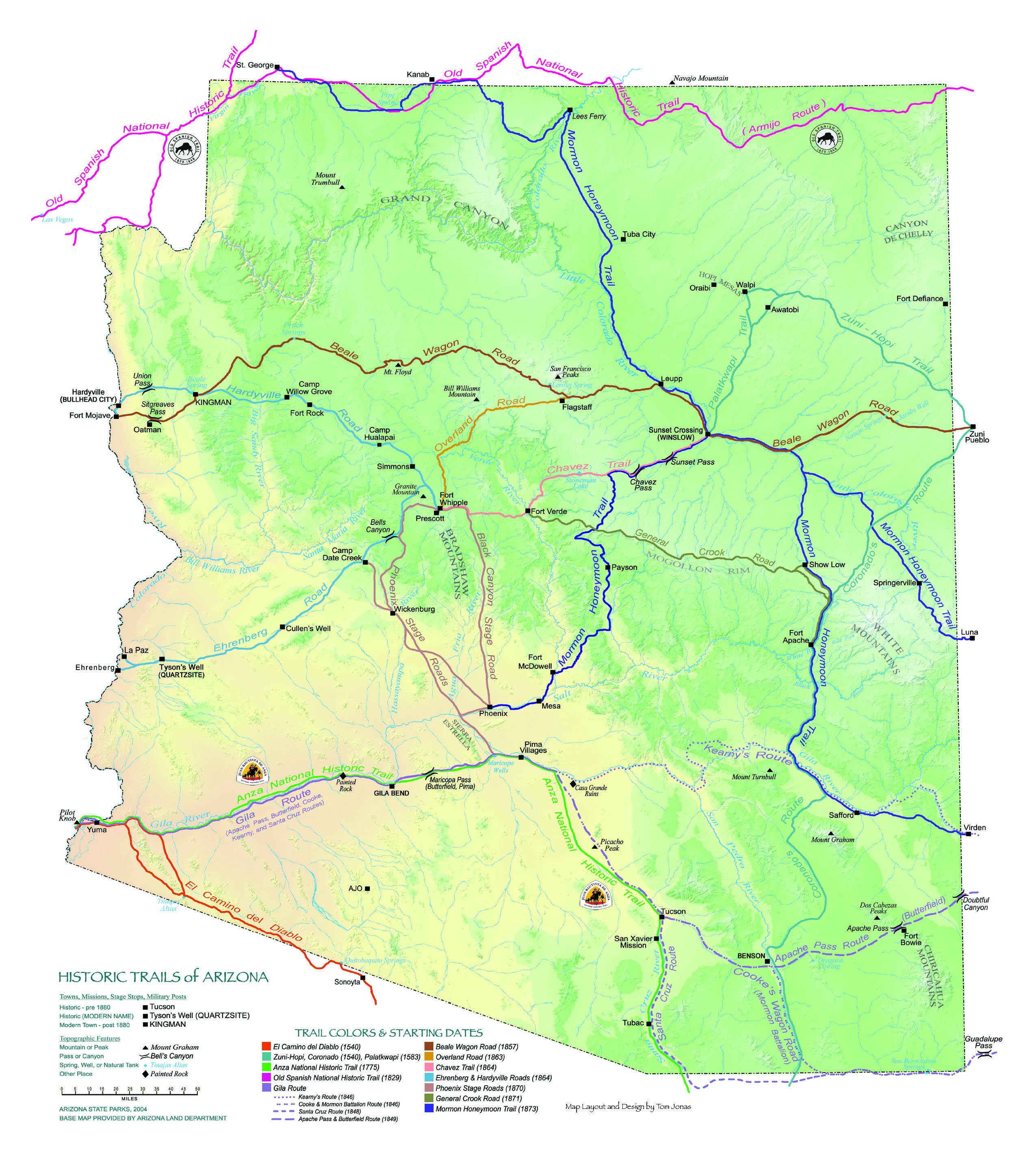
Historic Trails of Arizona
The historic trails included here have many stories to tell, of individuals like Martha Summerhayes and the countless families who endured hardships of early overland travel in search of a better life. These dirt traces were the lifeblood of the region, the supply, trade, and travel routes for Native Americans, conquistadores, explorers, surveyors, traders, trappers, miners, soldiers, missionaries, emigrants — men, women, and children — and yes, even gunfighters, renegades, bounty hunters, and bandits, always following the streams or heading to where there were springs of water. Simple things — water, forage for the animals, safety from marauders, and the most direct route possible — determined the route of travel. Today, a few vestiges of that stalwart past still remain, wagon tracks embedded in rock surfaces, iron traces left by metal wagon wheels, ruts and swales worn over time, bypassed now by modern vehicles.
Historic Trails Team
A group of volunteers and professionals in many fields of endeavor, all interested in preservation and protection of Arizona’s notable historic routes came together to produce the Historic Trails page. Arizona State Committee on Trails was instrumental in this effort. Each trail has its own unique story!
Historic Trails of Arizona - Gila Route
The southern overland route to California through present-day Arizona has been in use for centuries — first by Native Americans, then by Europeans. Learn More
Historic Trails of Arizona - Old Spanish National Historic Trail
The Old Spanish Trail, “the longest, crookedest, most arduous pack mule trail in the history of America,” was best-known during the Mexican period. Learn More
Historic Trails of Arizona - Prescott to Phoenix Stage Coach Routes
The Arizona & California Stage Company, headquartered in Wickenburg, provided passenger, mail, and light freight service to the west. Learn More
Historic Trails of Arizona - Mormon Honeymoon Trail
Mormon colonizers of Arizona traveled this route to St. George, Utah, to be married in the closest temple. Learn More
Historic Trails of Arizona - General Crook Road
In use for 32 years, this supply road created by General George Crook, connected Fort Apache to Fort Whipple. Learn More
Historic Trails of Arizona - Ehrenberg & Hardyville
The main supply route to Prescott and Fort Whipple, serving both military and civilians, was two 150-mile freight roads from the Colorado River. Learn More
Historic Trails of Arizona - Chávez Trail
The Chávez Trail, despite the general rough and rugged terrain, enjoyed a relatively even and straight 125 miles from Winslow westward to Prescott. Learn More
Historic Trails of Arizona - Overland Road
At the time it was most used, this road extended approximately 85 miles from Flagstaff (called “Antelope Spring” before 1876) to Prescott (Fort Whipple). Learn More
Historic Trails of Arizona - Beale Wagon Road
In 1856, Congress appropriated necessary funds to construct three wagon roads. The man selected to build one of the roads was Edward Beale. Learn More
Historic Trails of Arizona - Juan Bautista de Anza National Historic Trail
Some 240 people set out from Tubac, Arizona, on October 23, 1775 to establish a presidio and mission in the San Francisco Bay area. Learn More
Historic Trails of Arizona - Zuni-Hopi, Coronado & Palatkwapi
Don Francisco Vázquez de Coronado ventured through northern Mexico into Arizona in 1540 searching for the fabulous legendary “Seven Cities of Gold.” Learn More
Historic Trails of Arizona - El Camino del Diablo
Travelers have used El Camino del Diablo (The Devil’s Highway) for centuries. Today, recreational four-wheelers use it. Learn More


