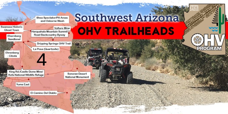
Region Four OHV Trailheads
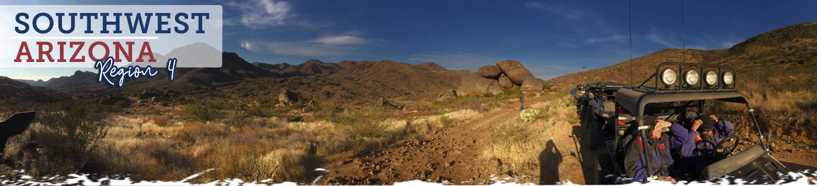
Southwest Arizona
The expansive Sonoran Desert country that stretches from Wickenburg westward to the Colorado River is loaded with epic Region 4 OHV experiences. Most riders avoid these southwestern AZ off-road adventures during the summer months as desert temps are well into triple digits, but the remaining seasons provide nearly perfect weather to explore any of the trails listed below. Within this region you’ll find sand dunes, saguaro forests, ghost towns, old mines, and expansive trails that start from a variety of convenient and scenic OHV trailheads.
Pro Tip: Regardless of season, drink plenty of water on your OHV adventure to avoid dehydration! It’s a good idea to pre-hydrate before your trip as well to ensure you’re properly hydrated before sweating it out during one of the following remote desert trail experiences.
You’ve found Arizona’s most current OHV trail resource! Select a trailhead location from the map and learn more about each unique off-road adventure below. Find out what to expect during your trip, access maps to each of the OHV trailheads, and have important land manager contact info right at your fingertips. We’re helping you plan so you can focus more intently on the adventure!
Click the Statewide OHV Trailheads button below to find even more awesome OHV experiences and trailheads throughout Arizona!
Alamo Lake State Park
For a new adventure, look no further than the expansive BLM trails just outside the campground at Alamo Lake State Park. This remote lake is known to be a fisherman’s paradise, but our hot tip is that it’s also for dirt road dreamers! Your campsite or cabin can serve as your own private staging area. Craggy slot canyons and the open sandy trails that span the flat between Arrastra and the Rawhide Mountains will quickly unleash your inner desert adventure spirit.
OHV Trail Access Map from Alamo Lake State Park
Arizona Peace Trail Staging Area
- Land Manager: Town of Quartzsite
- Providing access to the Arizona Peace Trail, this newly developed Arizona State Parks and Trails Funded trailhead offers 26 pull-thru parking spots, picnic area, restroom building, and security lighting. An onsite camp host helps keep facilities maintained and riders informed so that you can ride with ease.
Dripping Springs OHV Trail
- Land Manager: Bureau of Land Management - Yuma Field Office
- Follow a primitive road to gold mines and a spring starting 8 miles east of Quartzsite. There are many crossing roads in the area so navigation can be challenging. In Yuma, check out Colorado River and Yuma Territorial Prison state historic parks.
Ehrenberg Sandbowl
- Land Manager: Bureau of Land Management – Yuma Field Office
- The hilly, sandy terrain of the Ehrenberg Sandbowl makes this site a popular place for off-highway vehicle use. The area is a starting point for visitors to explore a variety of designated roads and trails. Dispersed camping is available nearby.
Ehrenberg-Cibola
- Land Manager: Bureau of Land Management - Yuma Field Office
- This area is located between the City of Ehrenberg, the City of Cibola, the Colorado River and the Yuma Proving Ground. Vehicle travel is limited to existing routes and is prohibited in the Trigo Mountain Wilderness. Visitors are asked to obey all warning signs and to call the Yuma Proving Ground at (928) 328-2720 for access information. The Cibola National Wildlife Refuge is at the south part of the area. Please obey signs and call the Refuge at (928) 857-3253 for information. This area is low desert and includes the spring, fall and winter seasons. In Yuma, check out Colorado River and Yuma Territorial Prison state historic parks. For maps and information contact the Bureau of Land Management, Yuma Field Office at (928) 317-3200 or via e-mail at yfoweb_az@blm.gov.
El Camino Del Diablo
- Multiple Land Managers: Bureau of Land Management | Organ Pipe Cactus National Monument (NPS) | Cabeza Prieta National Wildlife Refuge (USFWS) | Barry M. Goldwater Range (Marine Corps) Map
- This is a famous and remote 130-mile trail that spans from Ajo to Yuma. Plan one to three days for the trip. It is wise to bring a second vehicle and plenty of supplies as there are long stretches with no service and little to no interaction with other people. Although the trail is not very difficult from a technical perspective, there are many sections of deep sand and rocky washes. A free permit is required to cross the Barry Goldwater Air Force Range and it can be acquired at either the Marine Corps Air Station in Yuma or the Cabeza Prieta N.W.R. headquarters in Ajo.
Harquahala Mountain Summit Road Backcountry Byway
- Land Manager: Bureau of Land Management – Hassayampa Field Office
- The Harquahala Mountain Summit Road offers something for everyone! The road itself is rugged and challenging for OHV enthusiasts. For the nature lover, it has beautiful Sonoran Desert scenery with blooming flora March through May and distinct ecosystem variations can be seen with changes in elevation. In addition to the typical desert reptiles and critters which can be encountered, bighorn sheep may also be spotted. For the scenic enthusiast, the summit is the highest point in southwest Arizona with breathtaking 360 degree vistas. For hikers, a pack trail leads from the summit down the mountain through the Harquahala Wilderness Area designated in The Arizona Desert Wilderness Act of 1990. The trail has several difficult and steep portions. For the history buff, the drive displays old mining debris, shafts and stone houses from earlier miners. The grand finale is realized at the summit with the Harquahala Peak Observatory. The observatory was built by the Smithsonian in 1920 to measure and record solar activity. It was abandoned in 1925 and in 1975 was listed on the National Register of Historic Places and has since been stabilized.
King Road/Castle Dome Mine/Kofa National Wildlife Refuge
- Land Manager: United States Fish and Wildlife Service - Kofa National Wildlife Refuge
- Much of the Kofa National Wildlife Refuge is rugged, remote, and designated wilderness with the exception of marked motorized routes. Ride the King and Castle Dome Roads to traverse the area and access the Castle Dome Mine Museum. In Yuma, check out Colorado River and Yuma Territorial Prison state historic parks.
La Posa (Quartzsite)
- Land Manager: Bureau of Land Management – Yuma Field Office
- The La Posa Long Term Visitor Area (LTVA) was created in 1983 to fulfill the needs of winter visitors and to protect the local desert ecosystem from overuse. The campground is approximately 11,400 acres in size, flat landscape, sparsely vegetated with plants such as creosote bushes, palo verde trees, ironwood trees, mesquite trees and various species of cacti. La Posa LTVA offers solitude in a unique desert landscape and a variety of recreational opportunities such as hiking, wildlife viewing and rockhounding. In Yuma, check out Colorado River and Yuma Territorial Prison state historic parks.
Mittry Lake Wildlife Area
- Land Manager: Bureau of Land Management - Yuma Field Office
- The Mittry Lake Wildlife Area includes about 600 acres of water surface and 2400 acres of marsh or upland. A wide variety of vegetative and wildlife species can be found here, with a scenic backdrop of three mountain ranges. This area is jointly managed by the U.S. Bureau of Reclamation, and the Arizona Game and Fish Department. In Yuma, check out Colorado River and Yuma Territorial Prison state historic parks.
New Water Mountains
See Yuma East and La Posa
Parker 400 Desert Race Course
- Land Manager: Bureau of Land Management - Lake Havasu Field Office
- This desert racing event has been around since 1972. Although the course has changed over the years, it still offers three loops of about 136 miles. The race is usually on a weekend in late January or early February. The course offers a demanding, difficult route all year long. Parts of the course require vehicles to be highway-legal/licensed. Access is available near Parker, Arizona in La Paz County. This area is Low Desert and includes the spring, fall and winter seasons. Contact Bureau of Land Management, Lake Havasu Field Office at (928) 505-1200. Check out nearby Buckskin Mountain and River Island state parks, which offer campgrounds, hiking trails, and access to the Colorado River.
Senator Wash South Shore
- Land Manager: Bureau of Land Management - Yuma Field Office
- This recreational area covers 50 acres, and has flat terrain, and large gravel beaches for reservoir access. Facilities include 2 restrooms with flush toilets, outdoor showers, and drinking water. Visitors can launch small watercraft from the nearby boat ramp. Other activities include OHV riding, fishing, camping, wildlife watching, watercraft recreation, swimming, hiking, solitude, and sightseeing.
Shea Spectator/Pit Areas and Osborne Wash
- Land Manager: Bureau of Land Management - Lake Havasu Field Office
- Located east of Parker using Shea Road, much of the area is defined by post and cable, which are the boundaries of a race vehicle pit and spectator areas of the Parker 400 Desert Race. The braided Osborn Wash is adjacent and to the south of the Spectator Area. These locations combine to create excellent OHV riding and camping opportunities. This area is Low Desert and includes the spring, fall and winter seasons. Contact the Bureau of Land Management, Lake Havasu Field Office at (928) 505-1200.
Sonoran Desert National Monument
- Land Manager: Bureau of Land Management - Sonoran Desert National Monument
- The national monument is the most biologically diverse of the North American deserts, and captures a significant portion of that diversity including extensive saguaro cactus forest. The monument contains three distinct mountain ranges, the Maricopa, Sand Tank, and Table Top Mountains, as well as the Booth and White Hills, all separated by wide valleys. Visits to the Sand Tank Mountains, located south of Interstate 8, require a Barry M Goldwater Range permit. Motorized vehicles must remain on existing routes. Multiple Sonoran Desert state parks are nearby: Catalina State Park in Tucson, Oracle State Park just north of Tucson, Picacho Peak State Park, and Lost Dutchman State Park in Apache Junction. All but Oracle have campgrounds and all have great trails.
Swansea Historic Ghost Town
- Land Manager: Bureau of Land Management – Lake Havasu Field Office
- Mining in the Swansea Area began around 1862, but major activity had to wait for the coming of the railroad. In 1904, the Arizona and California Railroad began constructing a line from Wickenburg to Parker. Seeing an opportunity for further development several of the original miners, Newton Evans and Thomas Jefferson Carrigan, secured investment money and began to develop Swansea. By the end of 1908, a 350 ton capacity furnace, a 3.5 mile water pipeline from the Bill Williams River, and the hoists for five mine shafts were under construction. By 1909 Swansea had a population of 500. The following year the Arizona and Swansea railroad began operation from Bouse. The railroad was key in moving supplies and people in and out of the growing mining town. Financial problems set in by 1911 and the mines shut down with a brief reopening in 1912. The American Smelting and Refining Company bought the mines in 1914 and rebuilt much of the town. The new owners ran the mines until 1937 when the Great Depression closed the mines for good.
Vulture Mine
- Land Manager: Bureau of Land Management - Hassayampa Field Office
- Routes near Vulture Mine pass through the beautiful Lower Sonoran Desert landscapes and offer excellent views of the 3660' Vulture Peak. Some routes include some tight technical driving with some stretches through sandy washes.
Yuma East
- Land Manager: Bureau of Land Management - Yuma Field Office
- This area is located in Yuma and Maricopa Counties between Interstates 10 and 8, with the Yuma Proving Ground (928-328-2720) and Kofa National Wildlife Refuge (928-783-7861) to the west. Please call for access information. The area encompasses a large portion of the Arizona Game and Fish Department's Hunting Unit 41. Vehicle travel is limited to existing routes. There is no vehicle travel in wilderness areas. Please obey all warning signs. This area is low desert and includes the spring, fall and winter seasons. Contact the Bureau of Land Management, Yuma Field Office at (928) 317-3200 or via e-mail atyfoweb_az@blm.gov.

