
Maps
Dead Horse Ranch Locator Map
Park location information, maps, driving directions and coordinates for Dead Horse Ranch State Park in central Arizona near Cottonwood, AZ 86326. Get to know this beautiful park and associated trails through maps when planning your trip so you can dive right into adventure upon arriving to the park.
What3Words: ///vague.waging.snarl
Dead Horse Ranch Park Map
Download Printable Park Map
Park Map shows you an overview of the park, including trails and camping sites.
Elevation
3300 ft
Dead Horse Ranch Trails Map
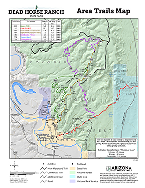 Park Trails Map (Color)
Download Park Trails Map (Color)
Trails in the park. Color version.
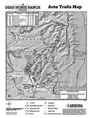 Park Trails Map (Black & White)
Download Park Trails Map (Black & White)
Trails in the park. Black & White version
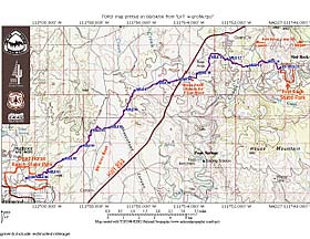
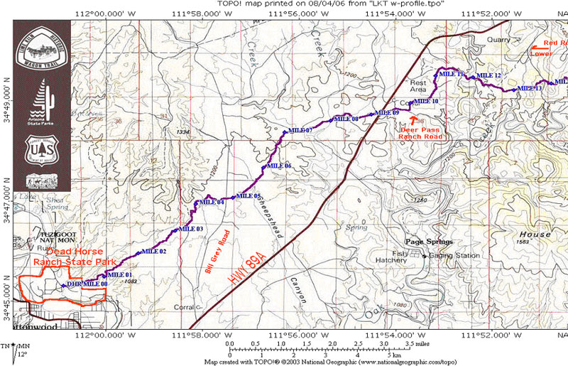
Lime Kiln Trail Topography & Segment Map
 Lime Kiln Trail
The Lime Kiln Trail is a 15 mile shared use trail that connects Red Rock and Dead Horse Ranch state parks.
Download Lime Kiln Trail Map
The Lime Kiln Trail goes from Dead Horse Ranch State Park to Red Rock State Park. This trail follows an old wagon trail and is a shared-use trail.
Download the previous version.
Verde River Greenway Paddle Map
Paddle Map 1: Tuzigoot Bridge to the Highway 89A Bridgeport Bridge
Download Paddle Map 1
Paddle Map 2: Beasley Flat to Sheep Bridge
Download Paddle Map 2
Paddle Map 3: Highway 89A Bridge to Beasley Flat
Download Paddle Map 3
Share the Trail
Understanding shared-use trail etiquette can make hiking, biking, and riding trails more enjoyable for everyone. Learn some basic principles and tips for using shared-use trails. Learn more.
GPS Coordinates to park entrance
 Lime Kilm Trail Map
Decimal Degrees (WGS84)
Latitude: 34.753082
Longitude: -112.022116
Degrees, Minutes & Seconds
Latitude: N34 45 11
Longitude: W112 01 19
GPS
Latitude: N 34 45.185
Longitude: W 112 01.327
UTM 12N
X: 406449
Y: 3846137

